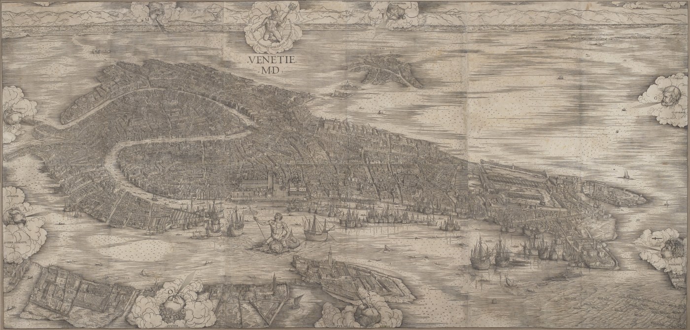
Consisting of six large sheets, the famous 1500’s woodcut (Venetie MD) by JACOPO de’ Barbari was a monumental feat of printmaking (135 by 282 cm).1 It took three years to complete, composing a southwest view of the city projecting viewers to a height of 500 metres, a position previously unimaginable. Yet, the naturalistic detail of the Venice it depicts also draws viewers towards the particulars of topography.2 Venice seems to emerge from the water framed by the Guidecca, the mainland, the mythological figures of Neptune, Mercury, and eight wind gods, who waft their winds towards its islands. Viewers enter the scene from the south, gazing over Giudecca’s suburban villas and gardens. Looking further into the distance, the viewpoint shifts north revealing the compact mass of the city. Galleys and smaller boats animate the lagoon, completing the rendition of the view as it would appear to the human eye from a position over the bell tower of San Giorgio Maggiore. Exaggerations of proportions and the composition give emphasis to a number of monuments, particularly the Piazza San Marco and the Piazzetta with the Ducal Palace, the Campanile, the Basilica of San Marco, and the central wing of the Torre del’ Orologio. The Rialto Bridge (before the fire) is also clearly visible, arching over the Grand Canal, while the expansive site of the Arsenale dominates the print on the eastern fringe of the city. Although these buildings are clearly recognisable, the density and detail of the topography give the city a uniform image. The whole presides over the parts, and every building contributes to the compact appearance of the city.
Expressing Venice’s imperial and mercantile power, the figures of Neptune and Mercury direct the viewer to the commercial and political centres of the Rialto and San Marco.3 With title and date stamped at the top – ‘At Venice 1500’ (VENETI[A]E) – the print declares its own historical significance. The naturalistic urban features and these historical ‘facts’ are invoked as real ‘data’ to bear evidence of the spectacular setting and the commonwealth of Venice. The publisher, Anton Kolb, had commissioned the view ‘for the glory of this illustrious city’.4 Yet, the purpose of the typographical image remains unclear. It did not serve a technical cartographical purpose, such as fixing property lines or recording data essential for military, architectural or urban planning.5 Schulz concludes that it was a map of didactic content that used geographical and topographical facts to construct a moralising portrait of the city, in the tradition of the Mappae Mundi (medieval world maps) produced in the fifteenth century by Venetian cartographers.6 Kolb had commissioned a work of ‘high Renaissance art’ in the ‘astro-mythological vocabulary of the humanists and incarnated in forms of an almost obsessive naturalism’.7
In the next blog entry I will explore how the print externalises spatial relationships in the city’s spatial networks and expresses them geometrically, making them accessible all at once to the eye.
1. Each panel measured approximately 66 by 99 cm, twice the width of the paper used for imperial folios. See: Deborah Howard, “Venice as a Dolphin: Further Investigations into Jacopo de’ Barbari’s View,” Artibus e Historiae 38, no. 35 (1997).
2. Wilson, The World of Venice.
3. Mercury, god of commerce, is encircled by the legend ‘I Mercury shine favourably on this above of all other emporia’. Neptune, god of the sea, carries the legend ‘I Neptune reside here, smoothing the waters at this port’. Schultz, “Jacopo de’ Barbari’s View of Venice”, 468.
4. Petitioning for the Venetian government for sole publication rights to the print, the publisher Anton Kolb described it as showing ‘the city of Venice just as it lies and is situated’. Schultz, “Jacopo de’ Barbari’s View of Venice”, 472.
5. In the earliest record of an impression of the print, from 1627 it is listed as part of a princely collection together with other city views maps and works of art. See: Schultz, “Jacopo de’ Barbari’s View of Venice”. Intended for an international market but also appealing to Venetians, the print was rather a luxury item for collectors to be displayed on a wall and viewed from some distance. See: Howard, “Venice as a Dolphin.”
6. Mappamundi provided a synoptic image, or a syncretic view of the world teaching geographical and non-geographical facts. They consisted of rational information – by fifteenth century standards – overlaid on historical and classical events, biblical lands and mythical monsters. Medieval and early Renaissance artists used such city views for conceptual illustration and as emblems of ideas. A mappamundi decorated the public loggia at the Rialto market in Venice and wall maps of the world were made for the ducal audience chamber in the Ducal palace under Doge Francesco Dandolo (1329-1339). See: Schultz, “Jacopo de’ Barbari’s View of Venice”.
7. Schultz, “Jacopo de’ Barbari’s View of Venice” 468.
Jacopo de’ Barbari. View of Venice (1500), image sourced from: https://upload.wikimedia.org/wikipedia/commons/e/e2/Jacopo_de%27_Barbari_-_View_of_Venice_-_Google_Art_Project.jpg
