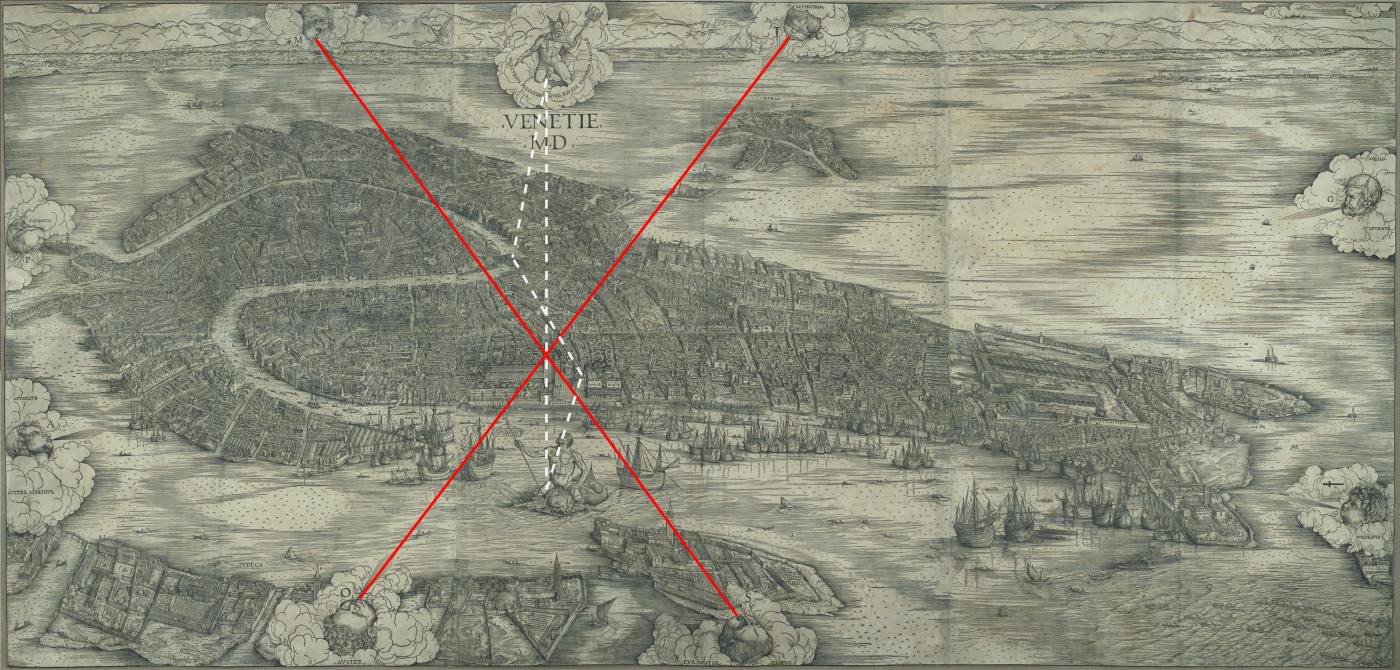
Looking closely at Jacopo de’ Barbari’s print, the earliest and largest naturalistic aerial view of the city that survives, we see that he used a geometric device, common to Mappae mundi. The vertical axis connecting the two mythological figures traverses the Orologio and runs between the two columns in the Piazzeta. While the columns guarded the entrance from the sea, the Orologio, which had been recently erected, signified entry to the Merceria, the set of streets that led to the Rialto. Two diagonal lines, established by the shafts of wind emanating from the eight gods that circle the city also organise the print, intersecting at the top of the Campanile. Between the pairs of vertical and diagonal lines, de’ Barbari establishes an axis mundi (a world pillar), placing the Piazza, the Rialto and the urban streets that connect them at the ‘centre’ of the city, and the city at the centre of an ideal cosmology. The Campanile – signalling the cosmological time of rituals – and the Orologio – measuring the time of business and clocks – are metonymically linked with the two Olympian gods and with Venice’s two urban centres. Jacopo’s image translated the empirical city into a transcendental mythical city of imperial achievement and republican ideology.
Imposing geometric centrality on the Rialto and San Marco, the print externalised their spatial and social significance and (made it available) to the viewers as a stable image. The Venetians and visitors familiar with Venice would be able, from the symbolic geometry and the physical facts of the topography, to perceive the pedestrian route between the two hubs as the urban spine of the city. However, the campi of various parishes are also clearly shown with their paving, toponyms, wellheads and bell towers. As viewers moved towards the surface of the wall on which the print would be displayed, the detail would encourage them to observe the cityscape as though they could see it from ground level. Due to the previously unimaginable viewing position, Jacopo’s Venice would have appeared physically and perceivably unknown, engaging them to identify their own houses with more perseverance than in previous illustrations. Aids to orientation were provided by the squares, which identified the local domain of every resident in the city.1 With their accentuated height, the bell towers would direct viewers from campo to campo, as though they experienced the spatial geography through spatial immersion. While situating the viewers simultaneously ‘inside’ and ‘outside’ a representation is a characteristic of all maps, Jacopo’s view intensively engages viewers in resolving a split between two places: mentally navigating through specific locations and surveying the whole through disembodied observation.
Jacopo’s view, Schultz wrote, ‘is so astonishingly and brilliantly detailed that one is apt to accept it unquestionably as a record of fact, but such confidence is misplaced’.2 Yet the synthesis of naturalism and inaccuracy is not its only contradiction. Like most works of art, it appropriates and distorts facts to articulate ‘fiction’.3 It is a record of topographical information and the fabrication of virtue. In its processes of translation, it synthesises vision from above with the mental projection of embodied vision back to the streets’ surface. Like almost every representation, the woodcut superimposes an artificial coherence onto the world, making us forget that the city is different from its image. In this way, it becomes an expression of suppressed tensions and reconciled contradictions: between the organic urban form and the aesthetics of symmetrical composition, between parochialism and civic glory, politics and commerce, city and nature, facts and fiction. In its centred and closed synoptic form, Jacopo’s map turns Venice into figurative pictorial discourse, expressing the imaginary relationship between ideology and spatial conditions.4
This is not to say that the ideal cosmology of Jacopo’s Venice was his own construct and not a product of the city and its people. On the contrary, the print attests to the parochialism and patriotism of medieval and Renaissance Venetians, as well as to the fact that Jacopo and Colb captured the heartbeat of the city. It is rather to stress that, as with every representation, in Jacopo’s print certain things are lost in translation. Being both factual and mythical, it raises the fundamental problem of deconstructing Venice’s Myth into its constituents – spatial relationships and ideology – in order to understand its internal conflicts. How did the symbolic instruments of Venetian identity relate to the city’s spatial geography, social and cultural institutions?
In the next blog entry I will explore this question by looking at two filters of information: first, the spatial organisation of the Piazza San Marco and the Bacino in the wider urban context of the city; second, the social and cultural filter related to civic rituals, popular myths and local traditions.
1. Wilson, The World of Venice.
2. Schultz, “Jacopo de’ Barbari’s View of Venice”, 439
3. It combined two ways of mapping: from the heights of towers and from the ground, expressing them as the imaginative transposition of embodied vision – that recognised streets, places and their relationships – and the totalising view of the metropolis. These two ways of perceiving Venice encompass the tension between experiencing the city as a pedestrian and grasping the unbroken unity of the urban body. They also expressed the dialogue between the mosaic of parish centres and the entire urban landscape. In the analysis of Venice’s urban networks, I noted that these spatial and social tensions had driven the development of the floating city. Jacopo’s map therefore, reveals a fair amount of knowledge about the urban form and the social organisation of the city based on parish centres. Yet, through its homogeneous detail and geometrical symmetry, the image calls viewers to marvel, against all diversity, at the unparalleled urbanity and unity of the whole.
4. Crouzet-Pavan explains that the city’s location in the lagoon had a profound influence on the development of the most serene Republic as an idealised picture. The lagoon was seen as a tranquil sanctuary protecting and separating the city from the continental affairs. With years it was reduced to a pacified element against the city’s spectacular theatricality. Elisabeth Crouzet-Pavan, “Towards an Ecological Understanding of the Myth of Venice,” in Venice Reconsidered: The History and Civilization of an Italian City-State, 1297-1797, ed. John Martin and Dennis Romano (Baltimore ; London: Johns Hopkins University Press, 2000), 42.
Image: adapted from Jacopo de’ Barbari. View of Venice (1500) by Sophia Psarra, The Venice Variations (2018)
